


2018 JUIN 25

FLOCON
User
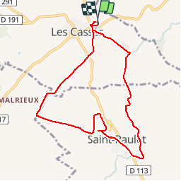

Length
9.3 km

Max alt
287 m

Uphill gradient
130 m
Km-Effort
11 km

Min alt
207 m

Downhill gradient
130 m
Boucle
Yes
Creation date :
2018-06-26 17:12:10.41
Updated on :
2018-06-26 17:12:10.41
2h24
Difficulty : Medium

FREE GPS app for hiking
 SityTrail
IGN / Geographical institutes
SityTrail Plus
The world is yours!
About
Trail Walking of 9.3 km to be discovered at Occitania, Aude, Les Cassés. This trail is proposed by FLOCON.
Description
LES CASSÉS 18 RANDONNEURS SOLEIL SOUS LES ARBRES DE LA RIGOLE
pUIS VISITE EXPLICATIVE SUR LA CULTURE DE LA TRUFFE.
Positioning
Country:
France
Region :
Occitania
Department/Province :
Aude
Municipality :
Les Cassés
Location:
Unknown
Start:(Dec)
Start:(UTM)
408779 ; 4808854 (31T) N.
Comments